Thank you for being patient whilst I struggle with trying to find an internet connection. I appreciate it has been three days since my last post but we are still here, still working our way north and all is well. I can get excellent signals in the middle of a bog but no or very poor signals in the valleys. Since we generally camp in the valleys I have not been able to post. So here goes...
Day 6 Malham to Horton in Ribblesdale.
After a very long and violent thunderstorm last night we
woke to a very clear and promising day.
If anything it was too hot for me; I carried 2 litres of water and drank
just about all of it. I also wore shorts, all day; the first time in said
attire since the first optimistic and later abandoned attempt on day 1.
The guidebook describes today as “special”. Wainwright
says “the limestone country around Malham is the best walkers’ territory so far
encountered along the Pennine Way and there is nothing better to come.” He was
not wrong. I know this area quite well and so knew what was to come but it
never fails to impress.
Malham Cove was first up and I arrived a bit too late to
get the best light; by the time I arrived after our drive from Settle the sun
was burning out the highlights on the grey limestone cliffs.
 |
| Malham Cove |
 |
| Looking back towards Malham from the top of Malham Cove |
There were not many people about, surprisingly few given
the weather. No climbers to be seen; perhaps a bit early for them. The path climbs up the side of the cove and
onto the limestone pavement at the top; a geographer’s paradise. Clints,
Grykes, dry and hanging valleys galore.
I was reminded of the video you can find on You Tube by Kite Stu (not
sure how you spell that) of water flowing over the top of Malham Cove in 2015
(?) for the first time in living memory.
No water today, dry as a limestone pavement despite last night’s storms.
Then on to Malham Tarn. I remember the first I saw the
Tarn as a teenager, I remember being bitterly disappointed. It was not what I
was expecting as I thought as a tarn it must be surrounded by steep mountains
having been gouged out of the rock by a glacier. I should have known better,
Malham Tarn is interesting because it is surrounded by porous limestone. There
should not be a lake there. It’s secret is that it sits on a bed of harder,
less permeable, rock, Silurian slate. Today I also learned that it is a very
important wet land habitat and is a nature reserve. There is a field centre at
the side of the lake and there were a party of rather bored looking school
children on what could only have been a biology field trip. They should
consider themselves very lucky! I
suspect, however that the geology field trip would be more interesting.
 |
| Malham Tarn |
Then it was the long gentle climb up onto Fountains Fell,
named after distant landowners from Fountains Abbey. There is a sign at the side of the path
warning of open mine shafts in the area. Wainwright says these are coal mines
which seems very strange to me but I live and learn. The view from the top of
Fountains Fell was truly shocking as I got my first close up view of
Pen-Y-Ghent, over which I was to climb, and it’s a monster!
 | |||||
| Top of Fountains Fell with the bulk of Pen-Y-Ghent in the distance |
 |
| Pen-Y-Ghent, the path goes up the left side, the steep side. |
Wainwright has a bit of a rant about Pen-Y-Ghent. Firstly
because he finds hyphens “irritating” and insists on calling it it Penyghent
and secondly because it is named as a hill.
He argued that it was a mountain not a hill. “It’s rough, stony and almost
precipitous on its south and west ridges and it sticks up like a huge stranded
whale on a beach… it’s an insult to describe it as a hill.” I am with him on
that except that Pen-Y-Ghent means “Hill of the Winds”, so I think he is on a
fruitless mission. In reality the climb up to the top of Pen-Y-Ghent was
steep but very short and the “summit” arrived very quickly.
 |
| Pen-Y-Ghent "summit" |
The same cannot be said of the descent into Horton. It
was long and tedious on a gravel path that wound its way down the hill by not
the most direct of routes.
We are now camped in a delightful little campsite in
Horton, between the café and the pub. I think it has been here for years but I
have never camped here before. It is
very small and basic but has an area in the car park for “Caravanettes” with
electric hook up and a two shower toilet block for the gentlemen but sadly only
one shower for the ladies. The proprietor, Chris, inhabits his own tent which
is like a Bedouin type of arrangement with colourful rugs across the ceiling
and numerous paintings and easy chairs and a sofa along with all sorts of
crockery and bric-a-brac stacked around the sides. It reminded me of Ben’s place in Local Hero.
Chris is very friendly, we exchanged pleasantries about the weather and last
night’s storm in particular and he explained that the gent’s was new and that
the ladies was a work in progress. We will have to come back here.
Catherine cycled 36 miles around Malham, Grassington and
Arncliffe (the original village in Emmerdale Farm, very interesting pub –
that’s another story). Her route was thwarted by road menders resulting in
newly laid tarmac adhering to new tyres. Tyres were duly scraped with a screw
driver to clean them of their burden. Hands completely wrecked!
Now off to sample the delights of the Golden Lion (I
think) and maybe take advantage of their wi-fi as there is no phone signal
here.
Guidebook said: 14.5 miles
Garmin says: 15.9 miles; 5.6mph max; 3.1mph moving
average; 2.5 mph overall average; 6hrs 21 minutes with 1hr 25 stoppages.
 |
| Highland Cattle above Malham Cove |
 |
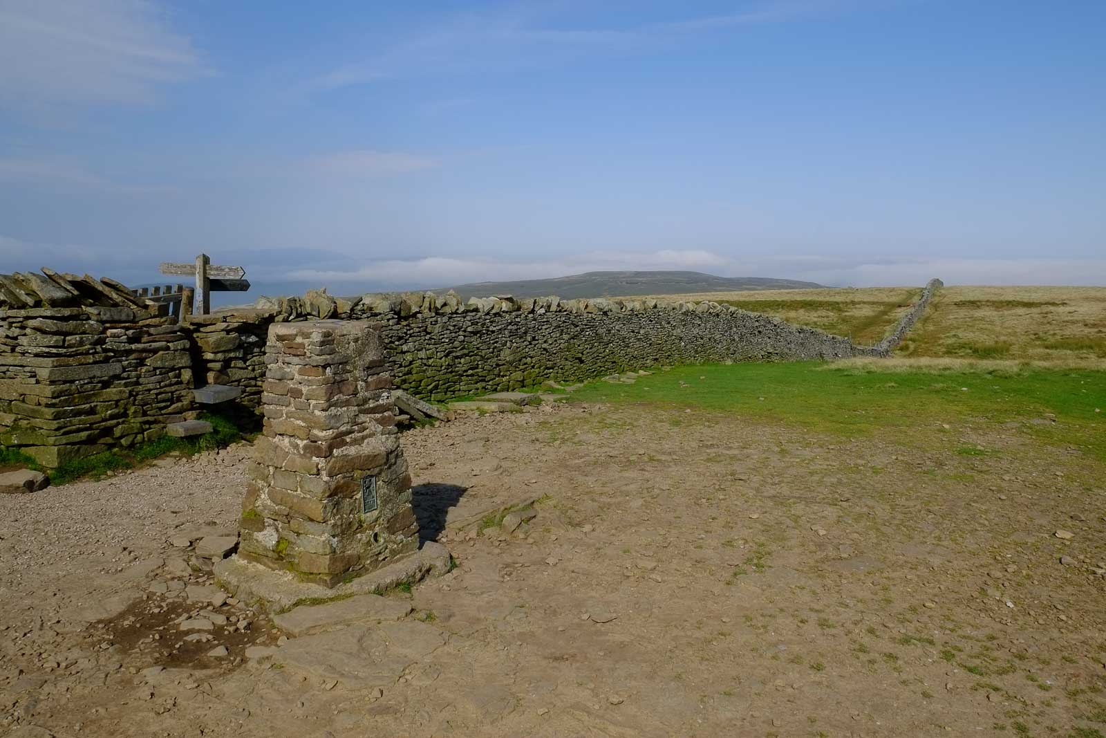
| Dont stray off the path, Fountains Fell top. |
AW
No comments:
Post a Comment